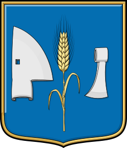
Coat of arms of Konyár
Lokáció:
Típus:
Jogállás:
Location of Konyár
Konyár is situated in Hajdú-Bihar County, within the Derecske District, approximately 30 kilometres south of Debrecen in the Northern Great Plain region of Hungary. It lies within the Berettyó river basin, on the edge of the historic Sárrét marshland, along the south-eastern fringe of the Hajduk settlement area.
The neighbouring settlements are Hajdúbagos to the north, Hosszúpályi to the northeast and east, Esztár to the southeast, Hencida and Gáborján to the south, Szentpéterszeg to the southwest, and Derecske to the northwest.
For centuries, the area’s marshy landscape and heavy clay soils determined local agricultural practices. Before the extensive river regulation works of the 19th century, the unique natural environment of the Sárrét region played a significant role in the development of the settlement.
History of Konyár
A major turning point in the history of Konyár came with the Hajduk settlements established in the early 17th century. The community developed around Hajduk inhabitants who were obliged to perform military service while also making their living through agriculture. This dual role shaped the character of the village for generations.
The settlement itself is considerably older, with its name already appearing in medieval written records. As part of the historic Bihar County, Konyár remained an agricultural settlement for centuries, its development closely linked to the natural conditions of the Berettyó River and the Sárrét marshland. Like many neighbouring communities, it suffered setbacks during the Ottoman occupation of Hungary but survived and gradually recovered during the 17th and 18th centuries.
The use of an official community seal is documented from the early 18th century. The seal matrix engraved in 1717 is one of the earliest surviving symbols of the village’s self-government and represents the historical predecessor of the present coat of arms. The principal motifs of the seal were preserved in the later coat of arms, allowing the emblem to reflect Konyár’s historical heritage for more than three centuries.
Main Landmarks
The settlement’s most significant historic monument is its Reformed Church, built in the 18th century and restored in 2006 with financial support from the European Union.
Other important heritage sites include the Kurucz Albert Village Museum and the traditional village house (Tájház), restored in 2020, both preserving the local folk culture and historical traditions.
East of the village runs the line of the Csörsz Ditch, also known as the Devil’s Ditch, a major Late Roman earthwork constructed most likely between AD 324 and 337. It is regarded as one of the most important archaeological and historical landscape monuments of the Great Hungarian Plain.
Coat of Arms of Konyár
The coat of arms of Konyár uniquely combines Hajduk traditions with the agricultural character of the settlement. The central motif of the 1717 seal is an ear of wheat. On the heraldic dexter side of the shield is a ploughshare, while the heraldic sinister side bears a battle axe, the characteristic weapon traditionally associated with the Hajduks.
Source of the original image: Nemzetijelkepek.hu

The visual content of this website may be freely used under the terms of the Creative Commons 4.0 license, provided that the source is clearly indicated and the attribution includes a full, clickable link to https://cimerek.hu or to the exact web address of the specific content.